Wonder beneath our feet, a journey down the Macho de Monte Canyon.

By David Dell
Panama’s newest, and possibly its most beautiful, stretch of highway will soon be officially open to the public. The road runs east to west from Potrerillos Abajo to Cuesta de Piedra in the western part of Chiriqui. Orginally it was supposed to link the two towns of Boquete and Volcan but a huge canyon outside Boquete has made that rather impossible.
VISITORS to Chiriqui in late February or early March will be in for a visual and aromatic treat as the road is lined with 12,000 acres of Valencia and native orange trees. The snow-white blossoms and fragrant perfume should provide travelers with a memory to last a lifetime. The altitude of some 2,500 feet also provides spectacular views down to the Pacific Ocean.
The Crow flying distance between Boquete and Volcan is just 15 miles, however in these rugged and tortuous miles there are many canyons, rivers and gorges. The new road takes twice as long as the existing route, so as a shortcut sadly it is not. As a wonderful scenic mountain drive, it certainly is. Waterfalls, swimming holes and breathaking trout bearing rivers are all along this drive. Its altitude means the temperatures will be in the pleasant mid 80’s F. So turn off your air-conditioning, open the car windows and have some free lung full’s of Panama’s sweetest and freshest air. Not fully paved throughout, but the road is drivable in a normal saloon car, however a 4x4 would be advisable for the unpaved gravel hills.
DIRECTIONS: If you start from the Boquete turn off from the Pan Am highway head north through Dolega. Set your odometer to zero and follow these simple directions. After passing through Dolega take the left fork toward Potrerillos. At the 15 miles mark the newly paved road curves left. You are now on the Ruta Sur or Orange Blossom Highway.
On your right you will see the Zapadora antique store a great place to stop for coffee and a visit. A little further on, also on the right is the factory of CITRICO S.A. These very nice people planted all the orange trees, so a quick yell of “mucho gracias” out of the car window would be proper at this point.
At the 20.5 mile mark, passing through the village of Palmira Real you will need to make a sharp LEFT turn. There are no signs so keep checking the odometer. Now you will be deep in orange grove country. A good time to stop the car and take some pictures. To your left will be the Pacific Ocean, to your right will be the towering 14,500 foot Baru Volcano (Panama’s highest peak). All around you, as far as the eye can see will be … Orange trees (5,000 hectares of them to be exact.) At 24.5 miles another sharp LEFT turn, again no signs.
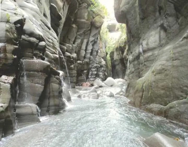
You will still be deep in orange country at 26 miles when you make a sharp RIGHT turn. At 26 miles the tarmac ends and you are now on graded gravel roads. Coming down a steep hill with several hairpin turns you come across workers finishing off the second major bridge on the route. To the right of the new bridge is the old metal suspension bridge. New and old side by side, a great Kodak moment. Climbing the hill you approach the village of El Paraiso and at 29.10 miles (thankfully) the black top resumes. In a few more miles you come to the bridge of the Rio Bregue. This is the second major bridge on the road. This one is completely finished. Climbing up from the bridge you will pass a spectacular waterfall to your right. Then after a few minutes you come to a “T” junction. From here you can continue to the right along a further scenic trip to Volcan or go left toward the village of Cuesta de Piedra. Go left, it’s worth it because after a few more miles you come to the deep canyon at Macho de Monte. Here you have several waterfalls and a stunning narrow canyon that has carved a gorge some 60 feet deep into the granite rock.
Then you can continue the last 12 miles north to Volcan, where right at the entrance to town you will find Dalys’s Restaurant.